OGC

Data Integration at the Land-Sea Interface

OGC Federated Marine Spatial Data Infrastructure Pilot 2024

Sponsored by:
United Kingdom Hydrographic Office (UKHO)
National Oceanic and Atmospheric Administration (NOAA)
National Geospatial-Intelligence Agency (NGA)
Supported by:
Ordnance Survey (OS)
United States Geological Survey (USGS)
Canadian Hydrographic Service (CHS)
Natural Resources Canada

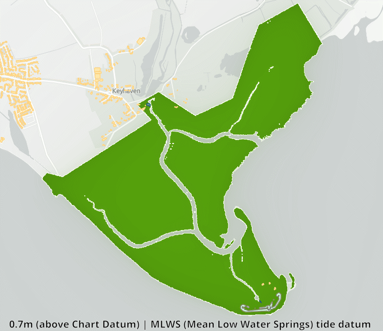
The White Ribbon Problem

The “white ribbon” is a metaphor for the intertidal zone—the ever-changing stretch of coastline that is alternately submerged and exposed by tides. This area is highly dynamic, constantly reshaped by tides, waves, and shifting sediments. It is also difficult to measure accurately with any single method. Responsibility for this zone is split between land and marine agencies, each using different tools, standards, and priorities. Though shaped by nature, it remains divided by gaps in data and governance.

Natural shoreline gradation diagram

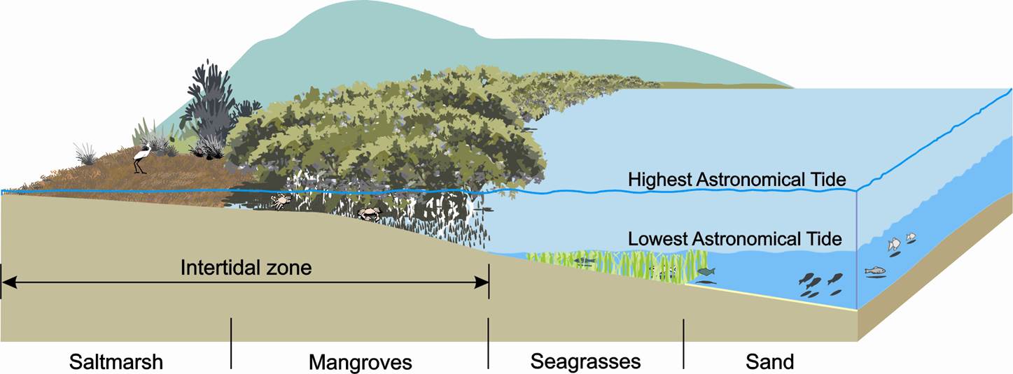
Figure 1. Natural shoreline gradation illustrating the land-sea interface. Source: NSW Department of Primary Industries – Fish Habitat Network.
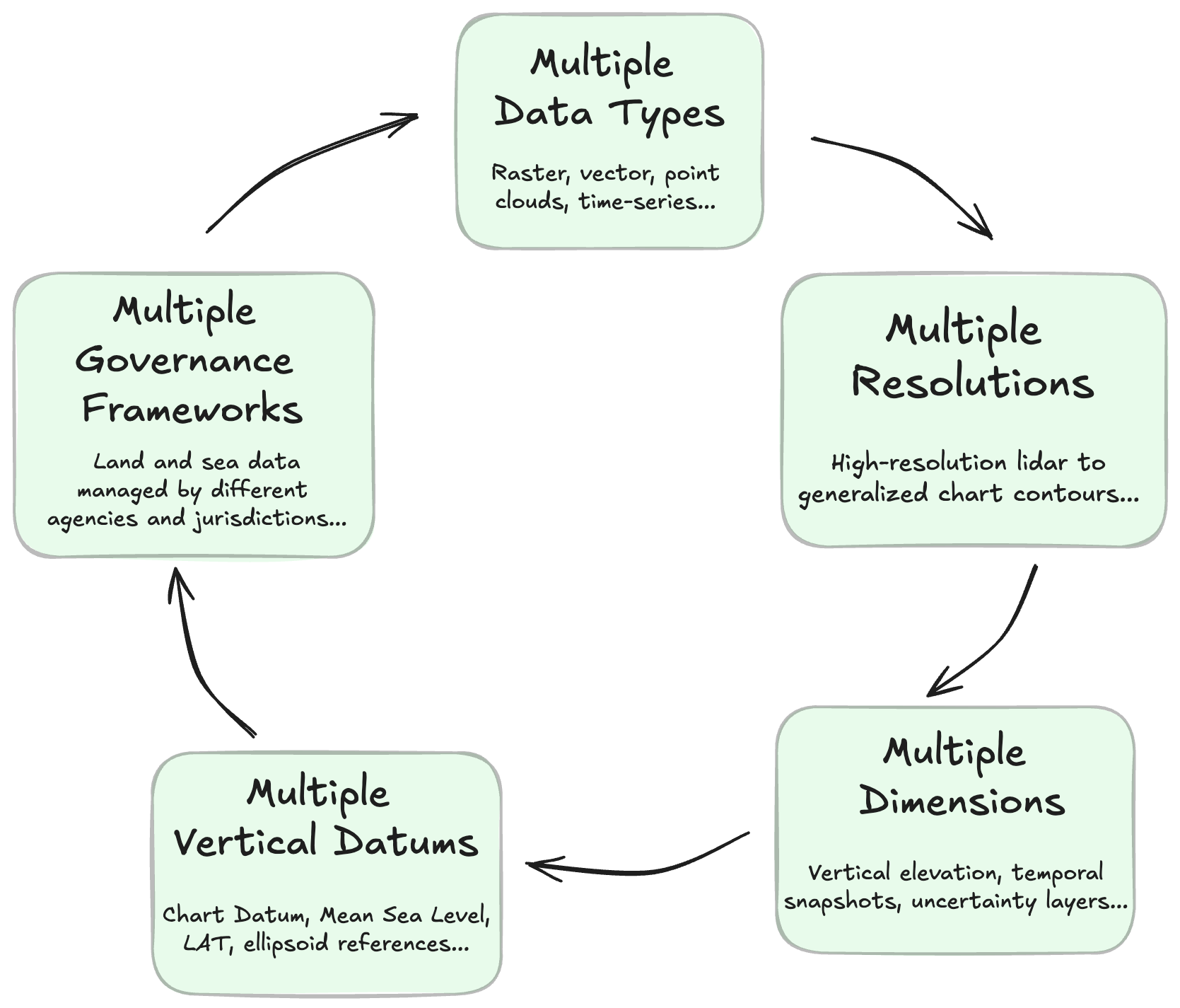

Data Gaps

  • Misaligned Datasets: Land and sea datasets often stop short of the shoreline or overlap without alignment, leaving the intertidal zone poorly defined.
  • Different Sensors: Land elevation is captured using LiDAR, while seabed depth uses sonar—resulting in mismatched resolutions and formats.
  • Inconsistent Standards: Agencies maintain data on different update cycles, spatial references, and file formats, making integration complex and error-prone.

Governance Gaps

  • Split Responsibilities: Land is managed by one set of authorities, the sea by another—leaving the intertidal zone in between with no clear ownership.
  • Conflicting Legal Frameworks: Different laws and regulations apply to land and sea, causing uncertainty in coastal planning and development.
  • Lack of Coordination: Agencies often work in silos, leading to duplicated efforts, missed opportunities, and disconnected priorities.

Why It Matters

  • Flood Risk: Incomplete data limits the accuracy of flood models and underestimates the impact of sea-level rise.
  • Emergency Response: Disconnected land-sea systems delay warnings and hinder response during coastal storms and surges.
  • Infrastructure Planning: Without integrated datasets, cities struggle to design resilient coastal infrastructure.
  • Environmental Protection: Fragmented monitoring makes it harder to detect and respond to threats in sensitive coastal ecosystems.
  • Trade & Transport: Ports, shipping, and logistics networks are disrupted by gaps in land-sea routing information.

Solving the white ribbon challenge, we unlock better resilience, smarter coastal planning, and stronger environmental stewardship.

Bridging Land and Sea

The fifth edition of the Federated Marine Spatial Data Infrastructure Pilot (FMSDI5) tackles one of the most challenging issues in geospatial science—integrating data across the land-sea interface. This transitional zone—where terrestrial and marine data systems converge—is marked by major interoperability barriers. These arise from differences in data standards, methodologies, spatial resolution, and update cycles across institutions. The complexity is further amplified by natural dynamics such as tides, erosion, sedimentation, and human activity, all of which continuously reshape the intertidal zone


Objective 1

Develop Draft Guide and Best Practices for Land-Sea Data Integration

Establish guidelines to ensure inter-agency interoperability for data concerning the intertidal zone, facilitating seamless data sharing and usage between terrestrial and marine communities.

Objective 2

Create Software Demonstrators for Dynamic Data Integration

Produce practical demonstrations that illustrate how existing datasets can be integrated in real-time with minimal information loss across land-sea boundaries, showcasing the effectiveness of proposed best practices.

Objective 3

Address Semantic and Technical Differences

Analyze and bridge the semantic and technical disparities between land and marine data models, ensuring that data from both domains can be transformed and utilized effectively within each other's conceptual frameworks.


Intertidal Data Dynamics

Figure 2. Dynamics of Intertidal Zones – Hurst Spit, UK example. Source: TCarta Inc., 2025.

Benefits of Integrating Land and Sea Data

Integrating land and sea geospatial data is essential for managing the coastal zone as a connected system. It enables smarter planning, stronger climate resilience, and better decision-making across a wide range of critical sectors.


Environmental Management

Supports ecosystem monitoring, shoreline change detection, and integrated conservation strategies at the land-sea interface.

Maritime Planning

Enables coherent marine spatial planning by linking offshore activities with terrestrial infrastructure and coastal policies.

Digital Twins

Provides continuous land-sea surface models for accurate simulations of flooding, erosion, and climate impacts.

Emergency Response

Improves risk assessment and situational awareness by unifying topographic and bathymetric data in real time.

Telecommunications

Enhances undersea cable routing and coastal infrastructure planning with seamless terrain-to-seabed models.

Finance

Informs coastal asset risk models and insurance pricing based on integrated hazard and exposure data.

Agriculture

Improves coastal land-use planning and salinity forecasting in farming regions affected by sea-level rise.

Defense

Enables better coastal surveillance, amphibious logistics planning, and sovereignty monitoring with unified datasets.

Alignment with UN SDGs

The pilot aligns closely with the United Nations Sustainable Development Goals (UN SDGs) and broader climate resilience objectives, reinforcing global efforts to combat the impacts of climate change and promote sustainable development.


SDG 11: Sustainable Cities and Communities

Supports sustainable coastal and urban planning by integrating land-sea data for better infrastructure management, risk reduction, and disaster preparedness.

SDG 13: Climate Action

Enhances climate resilience by improving geospatial data integration for coastal areas, supporting early warning systems, disaster risk management, and adaptation strategies.

SDG 14: Life Below Water

Supports the conservation and sustainable use of marine ecosystems by improving data accuracy in intertidal zones, aiding marine habitat protection, and enhancing coastal biodiversity monitoring.

SDG 17: Partnerships for the Goals

Fosters global collaboration between organizations, promoting open data standards, interoperability, and knowledge-sharing to advance geospatial solutions.

Intertidal Zone Geospatial Challenges

The intertidal zone is a dynamic and complex environment requiring standardized geospatial data for effective monitoring, conservation, and decision-making. However, achieving interoperability, accuracy, and consistency across datasets remains a significant challenge.


Lack of Unified Intertidal Data Standards

Despite advancements in marine spatial data infrastructures, intertidal datasets are often fragmented across agencies and organizations. Variations in data formats, classification schemes, and spatial resolutions hinder seamless integration and analysis.

Challenges in Vertical Datum Harmonization

Intertidal datasets often use different vertical datums (e.g., Mean Sea Level, Lowest Astronomical Tide, Mean Lower Low Water), complicating cross-regional comparisons and integration. Standardizing vertical references is essential for accurate coastal zone modeling.

Temporal and Spatial Inconsistencies

The intertidal zone experiences rapid changes due to tides, erosion, and sediment transport. Disparities in data collection frequencies, update cycles, and spatial resolutions lead to inconsistencies, making long-term trend analysis and habitat monitoring challenging.

Alignment with International Geospatial Standards

While standards such as IHO S-100 and OGC frameworks provide guidelines for marine spatial data, specific interoperability solutions for intertidal datasets remain underdeveloped. Harmonizing national datasets with international standards is necessary for cross-border marine spatial planning.

Integration with Marine Geospatial Platforms

Ensuring that intertidal zone data can be effectively integrated into existing marine geospatial platforms (e.g., GeoServer, Marine SDIs) is essential. Challenges include variations in projection systems, metadata inconsistencies, and limitations in high-resolution bathymetric datasets.


Data interoperability in intertidal zone management presents challenges across five key dimensions. Multiple data types arise from the diversity of formats and sources, requiring harmonization across structural and semantic levels. Multiple resolutions, both spatial and temporal, lead to mismatches that affect the consistency and comparability of datasets. Multiple dimensions, including 2D, 3D, and 4D data, require advanced spatial and temporal referencing techniques for effective integration. Multiple vertical datums must be reconciled to merge terrestrial and bathymetric data, as different providers use varying reference surfaces. Finally, multiple governance frameworks complicate coordination, as land and marine environments are managed by different agencies operating under separate legal and institutional mandates.

Intertidal Data Challenges

Figure 3. Addressing data interoperability challenges in the intertidal zone across five dimensions: data types, resolutions, dimensions, vertical datums, and governance. Source: Pangaea Innovations Pty Ltd, adapted by Hartis, 2025.

Information Modeling and Interoperability Best Practices

Effective marine spatial planning, coastal hazard assessment, and climate adaptation depend on the seamless integration of intertidal zone datasets within federated geospatial infrastructures. This integration is best supported by five core best practices that foster interoperability, enhance data quality, and enable decision-ready use across both land and sea domains.


Best Practice 1.
Unified Geospatial Reference

Adopt a modern vertical reference system based on the geoid (e.g., VORF, VDatum) to harmonize land and marine elevation datasets. Implement vertical separation surfaces to convert between tidal, orthometric, and ellipsoidal datums with precision. This enables accurate coastal inundation modelling and eliminates distortions at the land-sea boundary, particularly in the dynamic "white ribbon" zone.

Best Practice 2.
FAIR Data Principles

Ensure datasets are Findable, Accessible, Interoperable, and Reusable (FAIR). Include detailed metadata describing data quality, coordinate systems, vertical datum, acquisition methods, and uncertainties. Use internationally recognized standards like ISO 19115 and GeoDCAT-AP to support data sharing in federated catalogs. This allows seamless integration across domains and simplifies usage by automated pipelines and AI systems.

Best Practice 3.
Mind the Gap

Identify spatial or temporal gaps where land and sea datasets do not meet—often in the intertidal zone. Address gaps using remote sensing (e.g. satellite bathymetry, airborne LiDAR), targeted surveys, or interpolation when necessary. Carefully document methods and limitations, especially when interpolating seabed morphology, to ensure model reliability in flood risk analysis and resilience planning.


Best Practice 4.
Coordinated Governance

Apply multi-agency frameworks such as the UN-GGIM Integrated Geospatial Information Framework (IGIF-Hydro) to define roles and responsibilities across organizations managing coastal data. Promote data sharing agreements, joint policy development, and shared technical standards between land, hydrographic, and environmental agencies. This reduces duplication, resolves legal conflicts over data ownership, and accelerates climate risk mitigation and adaptation planning.

Best Practice 5.
Scalable Resolution Management

Use resolution-aware modelling techniques to integrate multi-scale data (e.g., high-res LiDAR with coarser sonar grids). Prefer point/vector data for accuracy and transformation flexibility. Tools like Triangulated Irregular Networks (TINs) or Discrete Global Grid Systems (DGGS) allow combining diverse datasets into unified coastal elevation models while preserving local detail. This approach enables precision analysis for coastal infrastructure while retaining broader context for regional planning.


For more information, refer to the full Draft Guide and Best Practices Engineering Report (approx. 39 pages / ~30–40 min read), which includes key terminology, governance frameworks, and technical guidance on land-sea data integration: Read Online (HTML) | Download PDF

FMSDI Case Studies

Pilot Areas & Prototype Demonstrators

Showcasing real-world applications of intertidal hydrospatial integration.


Target Areas of Interest (AOIs)

The Solent (UK)
A highly dynamic coastal region with significant land-sea interaction requirements.
Chesapeake Bay (USA)
A complex estuarine system with multiple data management challenges.

Technology Demonstrators

Compusult (D100)
Fusing land and marine datasets to support seamless coastal navigation and management.
Pangaea (D100)
Implementing a 4D DGGS framework to enable time-aware, unified geospatial analytics.
TCarta (D100)
Leveraging satellite-derived bathymetry for continuous monitoring of intertidal zones.

The Solent (UK)

A major strait separating the Isle of Wight from mainland England, known for its complex tidal phenomena, active ports, and critical intertidal ecosystems.


Key Challenges

Dynamic intertidal conditions impact navigation, infrastructure maintenance, and environmental management.

The double high water phenomenon extends tidal plateaus, complicating vessel movement and port operations.

Frequent wet-dry cycling accelerates infrastructure degradation, particularly in splash zones.

Rapid sediment movement and depth variability increase risks of vessel groundings and access restrictions.

Protected intertidal habitats require balancing commercial, recreational, and environmental priorities.

Effective operations rely on accurate bathymetric, tidal, and hydrodynamic data.

Inconsistent vertical datums across datasets complicate seamless spatial integration.

Pilot Goals

Integrate marine and terrestrial datasets to support sustainable coastal and port management.

Improve vertical datum transformation to bridge hydrographic and topographic datasets.

Promote adoption of OGC, IHO standards and FAIR principles for interoperable data exchange.

Enhance tidal and storm surge modeling to improve flood risk assessment and emergency planning.

Support erosion monitoring and port resilience through advanced geospatial visualization.

Leverage AI-driven remote sensing and satellite-derived bathymetry for dynamic shoreline monitoring.


Chesapeake Bay (USA)

The largest estuary in the United States, spanning six states with a watershed of over 64,000 square miles. It features dynamic tidal systems, extensive intertidal habitats, and complex coastal challenges.


Key Challenges

Disruptions in spatial continuity between terrestrial and marine datasets due to varying geospatial frameworks and coordinate systems.

Seasonal and tidal hydrodynamic shifts affecting navigation, sediment transport, and habitat stability.

Differences in spatial resolution, vertical datums, and projection methods across datasets.

Integration challenges across oceanographic, ecological, atmospheric, and human activity data layers.

Rising sea levels, increased storm surge exposure, and flooding risks threatening infrastructure and communities.

Pilot Goals

Harmonize bathymetric, topographic, and environmental datasets for improved spatial continuity and interoperability.

Achieve vertical datum alignment to support accurate tidal flooding and storm surge modeling.

Apply OGC standards and FAIR principles to strengthen cross-agency data integration.

Leverage machine learning and remote sensing to enhance sediment monitoring, shoreline mapping, and adaptation planning.

Utilize advanced visualization techniques to engage stakeholders in resilience planning and ecosystem management.


Compusult (D100)

Bridging the Gap Between Land and Sea – Enhancing Navigation and Coastal Management with Integrated Geospatial Data.

Compusult Demonstrator Link – To access the demonstrator, please request an account via the link provided.


The Challenge

Integrating land and sea datasets for intertidal navigation is complicated by differences in coordinate systems, resolutions, and formats, impacting accurate coastal analysis and decision-making.

Compusult’s Web Enterprise Suite (WES) creates a unified geospatial framework supporting navigation, environmental monitoring, and coastal management.

Approach

Data portfolios for The Solent and Chesapeake Bay integrate bathymetric, topographic, and tidal datasets from UKHO, NOAA, USGS, and Ordnance Survey.

An OGC API-based vessel navigation model simulates intertidal access, factoring in tide heights, bathymetric depth models, and digital elevation data.

Findings

Discrepancies between shoreline models impact coastal planning and infrastructure risk assessments.

Vertical datum misalignments led to early depth miscalculations, corrected by standardizing to chart datum.

Absence of infrastructure elements in models reduced simulation accuracy for flood and storm surge scenarios.

Key Actions

Incorporate critical infrastructure such as seawalls and berms into flood and surge simulations.

Standardize vertical datum transformations to maintain consistent depth modeling across datasets.

Expand simulation capabilities to include storm surge events and time-series tidal modeling.


Pangaea (D100)

Enabling a True Digital Nexus – Advancing Federated Marine Spatial Data Infrastructure with 4D DGGS.

Pangaea Demonstrator Link


The Challenge

Intertidal zones such as The Solent and Chesapeake Bay pose significant challenges for data integration, driven by differences in coordinate reference systems, vertical datums, and temporal inconsistencies. Traditional methods requiring extensive transformation slow down interoperability and scalability.

A scalable method is needed to unify terrestrial, marine, and atmospheric datasets without resampling or reformatting original data.

Approach

Pangaea applies 4D Discrete Global Grid Systems (DGGS) to index geospatial data across space and time, eliminating the need for coordinate transformations. TerraNexus 4D DGGS enables seamless integration across diverse datasets without altering native formats.

Demonstrations show how 2D, 3D, and 4D DGGS models enable rapid data indexing, retrieval, and federation without complex mathematical processing.

Findings

DGGS indexing removes the need for conventional coordinate transformations, greatly improving interoperability between terrestrial, marine, and atmospheric data.

Vertical datum inconsistencies persist due to gaps in metadata and height reference model availability.

4D DGGS significantly enhances machine-to-machine data discovery, although optimization for large-scale spatio-temporal queries remains an area for future work.

Key Actions

Develop harmonized 3D/4D visualization tools to improve DGGS-based data analysis and support complex queries.

Enhance metadata standards to ensure consistent and machine-readable vertical datum information.

Refine 4D DGGS tiling methods to efficiently integrate both static infrastructure and dynamic environmental datasets.


TCarta (D100)

Enhancing Coastal Situational Awareness – Leveraging Space-Based Sensors for Intertidal Zone Monitoring.

TCarta Demonstrator Link


The Challenge

Accurate monitoring of intertidal and coastal environments is essential for navigation, environmental protection, and coastal resilience. However, many existing coastline datasets are static, tied to a single water level or datum, and degrade in relevance over time.

Public awareness of dynamic tidal conditions remains limited, especially in unfamiliar areas. An accessible application that provides real-time spatial representations of the intertidal zone, attributed with tide model and gauge metadata, can help bridge this knowledge gap.

Approach

TCarta utilizes space-based sensors, including multispectral and Synthetic Aperture Radar (SAR) imagery, to generate wide-area bathymetric and intertidal datasets.

The approach integrates tide-gauge observations, historical tide models, and AI-driven classification to produce dynamic coastal products attributed with water-level metadata.

Findings

Coastline delineations vary based on sensor type, tide conditions, and temporal resolution.

Vegetation and seasonal variations affect multispectral imagery, while SAR is influenced by surface roughness and METOCEAN conditions.

Wide-area satellite imagery captures broad coastal changes but complicates data standardization due to local tidal variability.

Key Actions

Develop adaptive coastline models that dynamically update based on real-time water levels rather than static datums.

Enhance integration of space-based sensors with AI-based classification for improved accuracy and automation.

Leverage satellite altimetry where traditional tide-gauge infrastructure is sparse or outdated.


Stakeholder Perspectives

Effective stakeholder engagement is essential for shaping the Federated Marine Spatial Data Infrastructures (FMSDIs) to support intertidal zone management. Government agencies, research institutions, private sector entities, and non-governmental organizations (NGOs) play key roles in defining the use cases and technical requirements for intertidal zone data sharing. Their contributions help enhance decision-making for habitat conservation, resource management, and coastal resilience.


Collaboration Strategies

Inter-Agency Cooperation

Establishing frameworks for seamless data exchange and regulatory alignment between national and regional agencies.

International Data Sharing

Facilitating cross-border collaboration to improve marine spatial planning and environmental monitoring.

Community Engagement

Encouraging participatory approaches by involving local communities in data collection and decision-making.


Key Areas for Stakeholder Involvement

Interoperability Standards

Defining technical and data-sharing requirements to ensure intertidal datasets are accessible, harmonized, and compatible across platforms. This includes establishing common data formats, spatial reference systems, and metadata structures to support seamless integration.

Marine Spatial Data Standardization

Developing standardized frameworks for marine and intertidal spatial data to enhance usability and cross-border collaboration. This involves aligning with international standards such as IHO S-100, OGC, and ISO geospatial frameworks to improve data consistency and accuracy.

Policy Development & Data Accessibility

Establishing policies that promote equitable access to marine geospatial data while addressing governance, security, and intellectual property concerns. Encouraging open data initiatives and sharing frameworks to benefit scientific research and sustainable development.

Intertidal Zone Data Future Outlook

The FMSDI5 Pilot has demonstrated the transformative potential of space-based sensors, AI-driven analytics, and federated data sharing in advancing intertidal zone management. By integrating multi-source datasets, including satellite-derived bathymetry, machine learning-based shoreline classification, and 3D/4D DGGS spatial-temporal referencing, the pilot has significantly improved coastal monitoring for habitat conservation, and climate resilience. The development of a Draft Guide and Best Practices Report establishes standardized methodologies for data interoperability, tidal referencing, and geospatial integration, while Integrity, Provenance, and Trust (IPT) frameworks have the potential to ensure that marine geospatial data remains secure, verifiable, and accessible for cross-jurisdictional collaboration.


Strategic Directions

Coastline with Space-Based Sensors

Use satellite monitoring to capture and delineate coastal boundaries, improving the accuracy of intertidal datasets and supporting near-real-time environmental monitoring.

Expand Data Portfolios

Incorporate additional datasets and analysis-ready data (ARD), including time series for tide changes, storm surge simulations, and multi-source intertidal zone monitoring.

Integration of AI and ML

Apply machine learning and artificial intelligence to enhance shoreline classification, water-level detection, and environmental monitoring through automated geospatial analysis.


Key Research Priorities

Adopt 3D/4D DGGS for Tidal Referencing

Facilitate high-resolution spatio-temporal alignment of static infrastructure (e.g., ports) with dynamic tide level observations to improve marine data interoperability.

Incorporate Integrity, Provenance, and Trust (IPT) Layering

Leverage IPT technologies to authenticate data across jurisdictions, ensuring secure, immutable provenance tracking for marine spatial data.

Sponsors

The FMSDI5 Pilot acknowledges the invaluable role of its sponsors, whose commitment to advancing marine spatial data infrastructures goes far beyond financial support. They not only champion open collaboration, technological innovation, and sustainable practices, but also empower the hydrospatial community to push boundaries and deliver meaningful impact across — and beyond — the intertidal zone.

UKHO

For over 225 years, the UK Hydrographic Office (UKHO) has provided accurate and timely navigational data to support safe, efficient, and compliant maritime navigation.

NOAA

The National Oceanic and Atmospheric Administration (NOAA) enriches lives through science. From monitoring solar activity to exploring the ocean depths, NOAA keeps the public informed about our changing environment and works to protect lives and property.

NGA

The National Geospatial-Intelligence Agency (NGA) delivers cutting-edge geospatial intelligence that gives a decisive edge to policymakers, military personnel, intelligence professionals, and first responders.

Supporters

Ordnance Survey

Drawing on over 230 years of expertise, Ordnance Survey uses authoritative location data to enhance public services, drive economic growth, and support sustainable development—improving quality of life for millions of people.

United States Geological Survey (USGS)

The U.S. Geological Survey (USGS) provides impartial scientific data on landscapes, natural hazards, ecosystems, and water resources to support evidence-based decisions across the United States.

Canadian Hydrographic Service (CHS)

The Canadian Hydrographic Service (CHS) delivers hydrographic data, nautical charts, and water level information that support safe navigation and effective stewardship of Canada's waters.

Natural Resources Canada

Natural Resources Canada (NRCan) advances the sustainable development and responsible use of Canada's natural resources through science, mapping, and geospatial innovation.

Participants

The success of the Federated Marine Spatial Data Infrastructure 2024 (FMSDI5) Pilot is made possible through the collaboration of leading organizations dedicated to geospatial innovation, marine data integration, and sustainable coastal management. The following organizations have contributed expertise, technology, and resources to advance the goals of the Pilot.

HARTIS

HARTIS Integrated Nautical Services PC

Mission: Charting the Future of the Marine World

Responsible for: Engineering Report / Pilot Website (D001)

OceanWise

OceanWise

Mission: Marine Data Experts

Responsible for: Draft Guide and Best Practices Report (D002)

Pelagis Data Solutions

Pelagis Data Solutions

Mission: Data Driven Innovation for Marine Farming

Responsible for: Draft Guide and Best Practices Report (D002)


Compusult

Compusult

Mission: Geospatial Data Management Tech

Responsible for: Data Integration Demonstrator (D100)

Pangaea Innovations

Pangaea Innovations Pty Ltd

Mission: Spatial Data Integration Tech

Responsible for: Data Integration Demonstrator (D100)

TCarta

TCarta

Mission: Satellite-Based Hydrospatial Tech

Responsible for: Data Integration Demonstrator (D100)


Ordnance Survey

Ordnance Survey

Mission: National Mapping Service

Responsible for: Draft Guide and Best Practices Report (D002)


Key Contributions

Developing draft guide and best practices for interoperable marine data.
Advancing research in dynamic land-sea data integration.
Providing solutions for intertidal zone management.